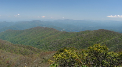
The Hangover, near the top of Haoe (HAY-oh) Mountain in the south central portion of the Joyce Kilmer-Slickrock Wilderness, provides one of the best panoramas in the southern Appalachians. On a reasonably clear day you can see ridges, valleys, and layered mountains in every direction—as well as part of the Lake Santeetlah community approximately eight air miles to the southeast.
Nevertheless, getting there and back demands at least an hour of driving plus six miles of fairly strenuous hiking. It’s possible to approach the Hangover via the Haoe Lead Trail, which begins off Maple Springs Road (1127) near Joyce Kilmer Memorial Forest, but the round-trip distance is more than ten miles and therefore beyond the ability of all but the most aggressive summer day hikers.
A shorter route to the Hangover originates from Big Fat Gap Trailhead at the end of USFS 62 (Slickrock Creek Road), a dirt-and-gravel road approximately seven miles from Lake Santeetlah and thirteen from Robbinsville. The junction of Road 62 with US 129 is obvious because you can see the bridge that crosses the Cheoah River on your left. (If you reach Cheoah Dam, you’ve gone too far.)
Slickroad Creek Road—closed in winter—winds uphill for 7.1 miles to the trailhead. (At 2.9 miles there is a small but well maintained turn-of-the-century cemetery in which most graves are marked only with rough fieldstones.)
Four trail paths diverge from Big Fat Gap. The trail to the Hangover, Hangover Lead Trail-South, rises quickly to the crest. (A “lead” is a prominent ridge “leading” to a mountaintop.) The trail moves in a generally southerly direction and includes occasional glimpses of mountain scenery, more often to the west.
The first and last thirds of the hike are pretty rough with a pathway containing many rocks and roots. Grassy Gap, about midway to the summit is a brief but welcome respite from a nearly continuous climb, which does indeed have grass as well as a comparatively open, level path.
As you near the top, the change in the forest is obvious; at 5000 feet the trees are mostly beech and yellow birch finally giving way to rhododendron. The view is glorious. In fact, the word “Haoe” is supposed to have been simply “an expression of beauty and exhilaration” on the part of an early mountain man who was “impressed by the splendor the landscape.”† Ironically, the top of Haoe Mountain itself (5, 249 feet) has virtually no view.

† Tim Homan, Hiking Trails of the Joyce Kilmer-Slickrock Creek & Citico Creek Wildernesses, 2nd ed. (Atlanta: Peachtree Publishers, 1998), 90.